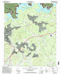
1994 Map of Marion East
USGS Topo · Published 1998About this map
Lake James dominates the northern landscape of this McDowell County region, where the Catawba River feed into its expansive blue waters. To the south, the industrial and residential outskirts of Marion take shape, including the established communities of East Marion, Clinchfield, and Stumptown. The infrastructure of the mid-1990s is clearly visible, from the Southern rail line to the State Prison Camp located near Jacktown.
Find a feature on this map
81 named features on this map. Tap any name to fly to it.
Don’t see what you’re looking for? This feature index may not catch every label — zoom into the map to look around manually.
Map Details
Editions of this 1994 Marion East Map
This is the sole edition of this map. No revisions or reprints were ever made.
Other maps of this area

1900 · Mount Mitchell
USGS Topo · 1:125,000

1902 · Mount Mitchell
USGS Topo · 1:125,000

1905 · Morganton
USGS Topo · 1:125,000

1953 · Charlotte
USGS Topo · 1:250,000

1954 · Charlotte
USGS Topo · 1:250,000

1955 · Knoxville
USGS Topo · 1:250,000

1956 · Oak Hill
USGS Topo · 1:24,000

1956 · Ashford
USGS Topo · 1:24,000

1956 · Linville Falls
USGS Topo · 1:62,500

1957 · Knoxville
USGS Topo · 1:250,000