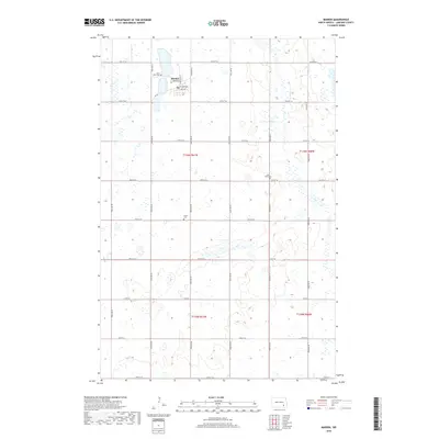
2018 Map of Marion
USGS Topo · Published 2018About this map
Marion serves as the central hub of this LaMoure County landscape, situated near the shores of a large unnamed lake. The town's grid is clearly defined by Center St, 4th Main Ave, and 3rd Ave, reflecting a typical prairie settlement pattern. This 2018 survey reveals a terrain heavily influenced by glacial activity, characterized by a high density of small wetlands and potholes interspersed between agricultural sections. The local genealogical record is anchored by three distinct burial sites: Lake View Cem just west of town, Saint Johns Cem to the east, and Grace Cem further south. A network of section-line roads, including 55th St SE and 100th Ave SE, provides the primary infrastructure for the surrounding rural territory, with Co Rd 35 acting as a significant east-west corridor through the lower half of the quadrangle.
Find a feature on this map
28 named features on this map. Tap any name to fly to it.
Don’t see what you’re looking for? This feature index may not catch every label — zoom into the map to look around manually.
Map Details
Editions of this 2018 Marion Map
This is the sole edition of this map. No revisions or reprints were ever made.
Other maps of this area

1894 · La Moure
USGS Topo · 1:62,500

1895 · Lamoure
USGS Topo · 1:125,000

1897 · Eckelson
USGS Topo · 1:125,000

1918 · La Moure
USGS Topo · 1:125,000

1952 · Dickey
USGS Topo · 1:24,000

1952 · Grand Rapids
USGS Topo · 1:24,000

1953 · Jamestown
USGS Topo · 1:250,000

1956 · Jamestown
USGS Topo · 1:250,000
1956 · Berlin
USGS Topo · 1:24,000

1970 · Litchville
USGS Topo · 1:24,000