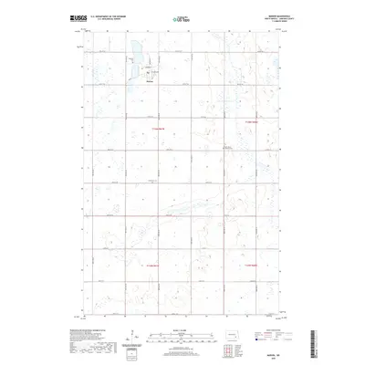
2020 Map of Marion
USGS Topo · Published 2020About this map
Marion serves as the primary hub of this eastern North Dakota landscape, organized around a traditional grid with streets such as Center St and 3rd Main St. The surrounding countryside in LaMoure County is defined by a dense network of sectional roads and glacial wetlands, illustrating the persistent agricultural geometry of the region. Local heritage is preserved at several points across the prairie, including Lakeview Cem situated just north of the town center, and the more distant Saint John's Lutheran Cem and Emmanuel Cem. The road network, comprising routes like Co Rd 35 and 99th Ave SE, connects these rural landmarks, reflecting a landscape that has remained largely consistent in its settlement pattern and land use over many decades.
Find a feature on this map
28 named features on this map. Tap any name to fly to it.
Don’t see what you’re looking for? This feature index may not catch every label — zoom into the map to look around manually.
Map Details
Editions of this 2020 Marion Map
This is the sole edition of this map. No revisions or reprints were ever made.
Other maps of this area

1894 · La Moure
USGS Topo · 1:62,500

1895 · Lamoure
USGS Topo · 1:125,000

1897 · Eckelson
USGS Topo · 1:125,000

1918 · La Moure
USGS Topo · 1:125,000

1952 · Dickey
USGS Topo · 1:24,000

1952 · Grand Rapids
USGS Topo · 1:24,000

1953 · Jamestown
USGS Topo · 1:250,000

1956 · Jamestown
USGS Topo · 1:250,000
1956 · Berlin
USGS Topo · 1:24,000

1970 · Litchville
USGS Topo · 1:24,000