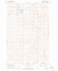
1970 Map of Marion
USGS Topo · Published 1973About this map
Marion serves as the central hub of this prairie landscape, situated at the junction of the Northern and Burlington railroad lines. The surrounding terrain is organized into the civil townships of Sheridan, Grandview, and Gladstone, reflecting the structured agricultural settlement patterns of the late 20th century. Local family and community history is preserved through numerous rural burial sites, including Lake View Cem, St Johns Cem, and Grace Cem, which are scattered among the section lines and small potholes that dot the plains. A dedicated National Wildlife Management Area in the south and a Gravel Pit near the eastern border illustrate the dual focus on natural conservation and local industry. The map is particularly notable for its inclusion of fine red dashed lines that indicate selected fence and field lines as they appeared during 1969 aerial photography, providing a high level of detail for those studying historical land use.
Find a feature on this map
15 named features on this map. Tap any name to fly to it.
Don’t see what you’re looking for? This feature index may not catch every label — zoom into the map to look around manually.
Map Details
Editions of this 1970 Marion Map
This is the sole edition of this map. No revisions or reprints were ever made.
Other maps of this area

1894 · La Moure
USGS Topo · 1:62,500

1895 · Lamoure
USGS Topo · 1:125,000

1897 · Eckelson
USGS Topo · 1:125,000

1918 · La Moure
USGS Topo · 1:125,000

1952 · Dickey
USGS Topo · 1:24,000

1952 · Grand Rapids
USGS Topo · 1:24,000

1953 · Jamestown
USGS Topo · 1:250,000

1956 · Jamestown
USGS Topo · 1:250,000
1956 · Berlin
USGS Topo · 1:24,000

1970 · Litchville
USGS Topo · 1:24,000