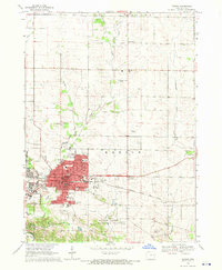
1968 Map of Marion
USGS Topo · Published 1970About this map
Marion is depicted here as a growing hub in Linn County, Iowa, during the late 1960s. The town's grid is dense with civic infrastructure, featuring a Post Office, City Hall, Library, and a wide array of local schools including Washington Sch, Lincoln Sch, and Linn-Mar Sch. The Chicago Milwaukee St Paul and Pacific railroad bisects the community, underscoring its historical importance to the region's transport network.
Find a feature on this map
56 named features on this map. Tap any name to fly to it.
Don’t see what you’re looking for? This feature index may not catch every label — zoom into the map to look around manually.
Map Details
Editions of this 1968 Marion Map
3 editions found
Other maps of this area

1887 · Cedar Rapids
USGS Topo · 1:62,500

1888 · Marion
USGS Topo · 1:62,500

1889 · Marion
USGS Topo · 1:62,500

1890 · Anamosa
USGS Topo · 1:62,500

1891 · Mechanicsville
USGS Topo · 1:62,500

1891 · Cedar Rapids
USGS Topo · 1:62,500

1894 · Mechanicsville
USGS Topo · 1:62,500

1900 · Anamosa
USGS Topo · 1:125,000

1901 · Stanwood
USGS Topo · 1:125,000

1903 · Fairfax
USGS Topo · 1:125,000