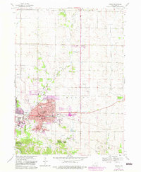
1968 Map of Marion
USGS Topo · Published 1983About this map
The city of Marion is captured here during a period of significant late-20th-century expansion into the surrounding Linn County farmland. Purple-tinted updates illustrate the rapid suburban growth encroaching upon rural areas like the County Home and the valley of Indian Creek. This development pattern is anchored by an extensive educational network, including the Linn-Mar Sch and Vernon Park Jr High Sch, alongside numerous neighborhood campuses like Washington Sch and Emerson Sch. Local industry and infrastructure are represented by the Illinois Central railroad corridor and the Marion Airport to the east. Beyond the expanding residential blocks, the landscape maintains its traditional character through sites such as Oakshade Cem and the sprawling Squaw Creek County Park, while the northern reaches remain defined by the winding paths of Berrys Run and East Indian Creek.
Find a feature on this map
64 named features on this map. Tap any name to fly to it.
Don’t see what you’re looking for? This feature index may not catch every label — zoom into the map to look around manually.
Map Details
Editions of this 1968 Marion Map
3 editions found
Other maps of this area

1887 · Cedar Rapids
USGS Topo · 1:62,500

1888 · Marion
USGS Topo · 1:62,500

1889 · Marion
USGS Topo · 1:62,500

1890 · Anamosa
USGS Topo · 1:62,500

1891 · Mechanicsville
USGS Topo · 1:62,500

1891 · Cedar Rapids
USGS Topo · 1:62,500

1894 · Mechanicsville
USGS Topo · 1:62,500

1900 · Anamosa
USGS Topo · 1:125,000

1901 · Stanwood
USGS Topo · 1:125,000

1903 · Fairfax
USGS Topo · 1:125,000