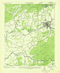
1935 Map of Marion
USGS Topo · Published 1935About this map
Marion serves as the focal point for this Smyth County landscape, situated where the Norfolk and Western railway and U. S. Highway No 11 parallel the Middle Fork Holston River. The town is notable for its concentration of institutional and community sites, including the State Hospital, the local Fair Grounds, and several cemeteries. To the north, the establishment of Hungry Mother State Park is documented, featuring Hungry Mother Lake and a C C C Camp, reflecting New Deal-era conservation efforts.
Find a feature on this map
66 named features on this map. Tap any name to fly to it.
Don’t see what you’re looking for? This feature index may not catch every label — zoom into the map to look around manually.
Map Details
Editions of this 1935 Marion Map
This is the sole edition of this map. No revisions or reprints were ever made.
Other maps of this area

1889 · Wytheville
USGS Topo · 1:125,000

1891 · Abingdon
USGS Topo · 1:125,000

1892 · Wytheville
USGS Topo · 1:125,000

1894 · Abingdon
USGS Topo · 1:125,000

1909 · Abingdon
USGS Topo · 1:96,000

1911 · Abingdon
USGS Topo · 1:125,000

1931 · Rural Retreat
USGS Topo · 1:48,000
1934 · Chatham Hill
USGS Topo · 1:24,000

1935 · Konnarock
USGS Topo · 1:24,000

1935 · Chilhowie
USGS Topo · 1:24,000