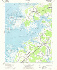
1942 Map of Marion
USGS Topo · Published 1970About this map
The coastal marshes and necks of Somerset County are meticulously documented in this 1942 survey, depicting a landscape defined by the Big Annemessex River and the Manokin River. The inland settlements of Upper Fairmount and Marion serve as hubs for the surrounding rural districts, including Brinkleys No 3 and Lawsons No 8. Transportation is anchored by the Pennsylvania (Crisfield Branch) railroad, which cuts through the southeastern quadrant. Small coastal communities like Rumbley and Fairmount are positioned along the intricate shorelines of Goose Creek and Fords Cove. This map captures a significant concentration of local heritage sites, from the Long Point Lt lighthouse and the Asb signal to a network of country houses of worship such as St Andrews Church, Wayman Church, and Samuel Webster Ch. The intricate naming of maritime features like Hazard Island and Mine Island reflects the historical importance of these waterways to the local economy.
Find a feature on this map
86 named features on this map. Tap any name to fly to it.
Don’t see what you’re looking for? This feature index may not catch every label — zoom into the map to look around manually.
Map Details
Editions of this 1942 Marion Map
2 editions found
Other maps of this area

1903 · Crisfield
USGS Topo · 1:62,500

1903 · Deal Island
USGS Topo · 1:62,500

1920 · Crisfield
USGS Topo · 1:62,500

1942 · Terrapin Sand Point
USGS Topo · 1:24,000

1942 · Great Fox Island
USGS Topo · 1:24,000

1942 · Marion
USGS Topo · 1:24,000

1942 · Deal Island
USGS Topo · 1:24,000

1942 · Monie
USGS Topo · 1:24,000

1942 · Kingston
USGS Topo · 1:24,000

1942 · Princess Anne
USGS Topo · 1:24,000