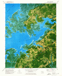
1972 Map of Marion
USGS Topo · Published 1975About this map
The Manokin River and the Big Annemessex River dominate this 1970s orthophotomap, revealing the intricate waterborne geography of Somerset County. This specialized survey overlays traditional topographic data onto aerial photography, providing a clear view of the marshlands and tidal necks that define the Chesapeake shoreline. Inland, the track of the Pennsylvania Central railroad connects the crossroads of Marion and Hopewell, while small settlements like Rumbley and Frenchtown cling to the edges of the salt marshes.
Find a feature on this map
102 named features on this map. Tap any name to fly to it.
Don’t see what you’re looking for? This feature index may not catch every label — zoom into the map to look around manually.
Map Details
Editions of this 1972 Marion Map
2 editions found
Other maps of this area

1903 · Crisfield
USGS Topo · 1:62,500

1903 · Deal Island
USGS Topo · 1:62,500

1920 · Crisfield
USGS Topo · 1:62,500

1942 · Terrapin Sand Point
USGS Topo · 1:24,000

1942 · Great Fox Island
USGS Topo · 1:24,000

1942 · Marion
USGS Topo · 1:24,000

1942 · Deal Island
USGS Topo · 1:24,000

1942 · Monie
USGS Topo · 1:24,000

1942 · Kingston
USGS Topo · 1:24,000

1942 · Princess Anne
USGS Topo · 1:24,000