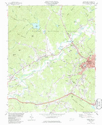
1985 Map of Marion West
USGS Topo · Published 1986About this map
Pisgah National Forest dominates the northwestern reaches of this map, where high points like Bald Mountain and Feds Mountain overlook the deep valleys of Buck Creek and Clear Creek. The central landscape is defined by the winding Catawba River, which supports a mix of agricultural land and early industrial sites such as a sand and gravel pit and several claypits. The city of Marion and its adjacent community, West Marion, serve as the regional hub, housing the County Courthouse, General Hospital, and essential transport links like the Southern railroad line.
Find a feature on this map
93 named features on this map. Tap any name to fly to it.
Don’t see what you’re looking for? This feature index may not catch every label — zoom into the map to look around manually.
Map Details
Editions of this 1985 Marion West Map
This is the sole edition of this map. No revisions or reprints were ever made.
Other maps of this area

1900 · Mount Mitchell
USGS Topo · 1:125,000

1902 · Mount Mitchell
USGS Topo · 1:125,000

1905 · Morganton
USGS Topo · 1:125,000

1934 · Parts Of Celo And Black Brothers
USGS Topo · 1:24,000

1934 · Parts Of Old Fort and Montreat
USGS Topo · 1:24,000

1953 · Charlotte
USGS Topo · 1:250,000

1954 · Charlotte
USGS Topo · 1:250,000

1955 · Knoxville
USGS Topo · 1:250,000

1956 · Ashford
USGS Topo · 1:24,000

1956 · Linville Falls
USGS Topo · 1:62,500