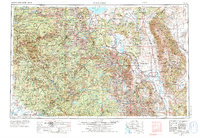
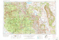
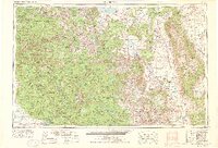
1957 Map of Mariposa
USGS Topo · Published 1976About this map
Yosemite Valley and the towering peaks of the Sierra Nevada define this mid-century topographic survey, showing the high-country landscape before modern expansion. This map captures the region's complex water management and power infrastructure, including the Hetch Hetchy Reservoir, Millerton Lake, and the winding Madera Canal that feeds the valley below. While much of the terrain is protected within Yosemite National Park and the Sierra National Forest, the map also details the smaller communities that supported regional tourism and industry, such as El Portal, Wawona, and Lee Vining. To the east, the Volcanic Tableland and the Owens River valley provide a stark contrast to the granite heights, featuring specialized industry at the Pine Creek Mine. Transit corridors like U.S. Highway 395 and the Southern Pacific RR facilitate movement across the state line into Nevada near Boundary Peak.
Find a feature on this map
80 named features on this map. Tap any name to fly to it.
Don’t see what you’re looking for? This feature index may not catch every label — zoom into the map to look around manually.
Map Details
Editions of this 1957 Mariposa Map
4 editions found

Other maps of this area

1891 · Big Trees
USGS Topo · 1:125,000

1893 · Sonora
USGS Topo · 1:125,000

1894 · Big Trees
USGS Topo · 1:125,000

1896 · Dardanelles
USGS Topo · 1:125,000

1896 · Sonora
USGS Topo · 1:125,000

1897 · Sonora
USGS Topo · 1:125,000

1897 · Big Trees
USGS Topo · 1:125,000

1897 · Yosemite
USGS Topo · 1:125,000

1898 · Dardanelles
USGS Topo · 1:125,000

1898 · Sonora
USGS Topo · 1:125,000
Featured Places
- Mammoth Lakes, CA
- Oakhurst, CA
- Coarsegold, CA
- Bishop, CA
- Dixon Lane–Meadow Creek, Dixon Lane-Meadow Creek