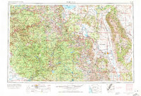
1957 Map of Mariposa
USGS Topo · Published 1971About this map
Yosemite National Park and the central Sierra Nevada dominate this landscape, showing the region as it transitioned into the early 1970s. The map illustrates a complex water management and power infrastructure, evidenced by major reservoirs like Hetch Hetchy Res, Huntington Lake, and Millerton Lake. While much of the terrain is protected within the Sierra National Forest and Inyo National Forest, industrial footprints remain visible at the Pine Creek Mine and Mount Morgan Mine.
Find a feature on this map
86 named features on this map. Tap any name to fly to it.
Don’t see what you’re looking for? This feature index may not catch every label — zoom into the map to look around manually.
Map Details
Editions of this 1957 Mariposa Map
4 editions found

Other maps of this area

1891 · Big Trees
USGS Topo · 1:125,000

1893 · Sonora
USGS Topo · 1:125,000

1894 · Big Trees
USGS Topo · 1:125,000

1896 · Dardanelles
USGS Topo · 1:125,000

1896 · Sonora
USGS Topo · 1:125,000

1897 · Sonora
USGS Topo · 1:125,000

1897 · Big Trees
USGS Topo · 1:125,000

1897 · Yosemite
USGS Topo · 1:125,000

1898 · Dardanelles
USGS Topo · 1:125,000

1898 · Sonora
USGS Topo · 1:125,000
Featured Places
- Mammoth Lakes, CA
- Oakhurst, CA
- Coarsegold, CA
- Bishop, CA
- Dixon Lane–Meadow Creek, Dixon Lane-Meadow Creek