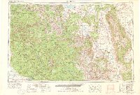
1957 Map of Mariposa
USGS Topo · Published 1976About this map
The high crest of the Sierra Nevada dominates this mid-century landscape, illustrating the dramatic elevation shifts between the Central Valley foothills and the high desert of the Owens River valley. This era reveals a region defined by federal land management and resource extraction, with the boundaries of Yosemite National Park, Sierra National Forest, and Inyo National Forest shaping the development of the high country. In the west, the Chowchilla Mountains and Sierra Nevada foothills are dotted with small communities like Mormon Bar and Ahwahnee, while the industrial presence is felt at the Pine Creek Mine and Mount Morgan Mine near the eastern escarpment.
Find a feature on this map
81 named features on this map. Tap any name to fly to it.
Don’t see what you’re looking for? This feature index may not catch every label — zoom into the map to look around manually.
Map Details
Editions of this 1957 Mariposa Map
4 editions found

Other maps of this area

1891 · Big Trees
USGS Topo · 1:125,000

1893 · Sonora
USGS Topo · 1:125,000

1894 · Big Trees
USGS Topo · 1:125,000

1896 · Dardanelles
USGS Topo · 1:125,000

1896 · Sonora
USGS Topo · 1:125,000

1897 · Sonora
USGS Topo · 1:125,000

1897 · Big Trees
USGS Topo · 1:125,000

1897 · Yosemite
USGS Topo · 1:125,000

1898 · Dardanelles
USGS Topo · 1:125,000

1898 · Sonora
USGS Topo · 1:125,000
Featured Places
- Mammoth Lakes, CA
- Oakhurst, CA
- Coarsegold, CA
- Bishop, CA
- Dixon Lane–Meadow Creek, Dixon Lane-Meadow Creek