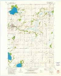
1980 Map of Markesan
USGS Topo · Published 1981About this map
The city of Markesan serves as the focal point of this 1980 survey, situated at the edge of the Grand River. This landscape at the start of the 1980s is defined by its agricultural character and water features, including Little Green Lake with its distinct Muskie Bay and Keartys Bay. The industrial presence of the era is marked by the Chicago Milwaukee St Paul and Pacific railroad line and several quarries, alongside specialized facilities like the Del Monte Corp Landing Strip.
Find a feature on this map
46 named features on this map. Tap any name to fly to it.
Don’t see what you’re looking for? This feature index may not catch every label — zoom into the map to look around manually.
Map Details
Editions of this 1980 Markesan Map
This is the sole edition of this map. No revisions or reprints were ever made.
Other maps of this area

1915 · Neshkoro
USGS Topo · 1:48,000

1916 · Ripon
USGS Topo · 1:48,000

1918 · Neshkoro
USGS Topo · 1:62,500

1918 · Ripon
USGS Topo · 1:62,500

1955 · Randolph
USGS Topo · 1:62,500

1955 · Fox Lake
USGS Topo · 1:62,500

1956 · Ripon
USGS Topo · 1:62,500

1957 · Madison
USGS Topo · 1:250,000

1960 · Madison
USGS Topo · 1:250,000

1963 · Neshkoro
USGS Topo · 1:62,500