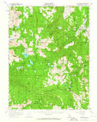
1956 Map of Markleeville
USGS Topo · Published 1964About this map
Markleeville sits as the central hub of this mid-century high-country survey, where the Carson River winds past Hangmans Bridge and the Gaging Sta. The map captures an era of active land management and resource extraction across the Toiyabe National Forest, Eldorado National Forest, and Stanislaus National Forest. The landscape is dotted with legacies of the mining era, including the Alpine Mine, Alhambra Mine, and the historic Silver Mtn (Site). High-altitude transit is documented through a network of jeep trails and significant crossings like Carson Pass and the Pacific Grade Summit. Water resources are abundant, from the large Upper Blue Lake and Lower Blue Lake complex to remote alpine basins like Winnemucca Lake and Nobel Lake, providing a clear record of the watershed before modern recreational expansion.
Find a feature on this map
116 named features on this map. Tap any name to fly to it.
Don’t see what you’re looking for? This feature index may not catch every label — zoom into the map to look around manually.
Map Details
Editions of this 1956 Markleeville Map
4 editions found

Other maps of this area

1889 · Pyramid Peak
USGS Topo · 1:125,000

1889 · Markleeville
USGS Topo · 1:125,000

1891 · Markleeville
USGS Topo · 1:125,000

1891 · Big Trees
USGS Topo · 1:125,000

1891 · Pyramid Peak
USGS Topo · 1:125,000

1893 · Markleeville
USGS Topo · 1:125,000

1894 · Big Trees
USGS Topo · 1:125,000

1895 · Pyramid Peak
USGS Topo · 1:125,000

1896 · Dardanelles
USGS Topo · 1:125,000

1896 · Pyramid Peak
USGS Topo · 1:125,000