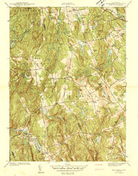
1944 Map of Marlboro
USGS Topo · Published 1944About this map
The hills of central Connecticut converge at the meeting of Tolland, Hartford, and Middlesex counties, where the Marlboro settlement sits near the banks of Lake Terramuggus. Surveyed in the early 1940s, this landscape is defined by its complex drainage systems, including the Blackledge River and Salmon River, which carved deep valleys through local heights like Birch Mountain and Baker Hill. Small rural schoolhouses such as White Sch and Northwest Sch are scattered throughout the townships of Hebron and Glastonbury, marking the social centers of these upland farming and timber communities.
Find a feature on this map
64 named features on this map. Tap any name to fly to it.
Don’t see what you’re looking for? This feature index may not catch every label — zoom into the map to look around manually.
Map Details
Editions of this 1944 Marlboro Map
5 editions found
Other maps of this area

1892 · Hartford
USGS Topo · 1:62,500

1892 · Tolland
USGS Topo · 1:62,500

1892 · Gilead
USGS Topo · 1:62,500

1893 · Middletown
USGS Topo · 1:62,500

1906 · Farmington
USGS Topo · 1:125,000

1921 · Tolland
USGS Topo · 1:62,500

1928 · Glastonbury
USGS Topo · 1:24,000

1928 · Manchester
USGS Topo · 1:24,000

1944 · Manchester
USGS Topo · 1:31,680

1944 · Marlboro
USGS Topo · 1:31,680