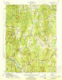
1944 Map of Marlboro
USGS Topo · Published 1944About this map
Marlboro and the surrounding Hartford and Tolland County landscape are captured here just before the mid-century, showing a rural New England network of small schoolhouses and family-named hills. The Blackledge River and Salmon River drain a terrain marked by numerous local schools like Birch Mtn Sch, White Sch, and Bolton South Sch, highlighting the decentralized community structure of the time. Evidence of the region’s earlier manufacturing can be seen along the watercourses, notably at Shoddy Mill Brook near the Townsend Cem. The area is anchored by Gilead and the shores of Lake Terramuggus, while the Fire Tower atop John Tom Hill stands as a prominent sentinel over the wooded ridges. This topographical study provides a detailed look at the 1940s road system, including the Boston and New York Road, before modern highway expansions altered these historic connectors.
Find a feature on this map
47 named features on this map. Tap any name to fly to it.
Don’t see what you’re looking for? This feature index may not catch every label — zoom into the map to look around manually.
Map Details
Editions of this 1944 Marlboro Map
5 editions found
Other maps of this area

1892 · Hartford
USGS Topo · 1:62,500

1892 · Tolland
USGS Topo · 1:62,500

1892 · Gilead
USGS Topo · 1:62,500

1893 · Middletown
USGS Topo · 1:62,500

1906 · Farmington
USGS Topo · 1:125,000

1921 · Tolland
USGS Topo · 1:62,500

1928 · Glastonbury
USGS Topo · 1:24,000

1928 · Manchester
USGS Topo · 1:24,000

1944 · Manchester
USGS Topo · 1:31,680

1944 · Marlboro
USGS Topo · 1:31,680