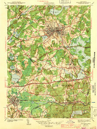
1943 Map of Marlboro
USGS Topo · Published 1943About this map
The urban core of Marlboro and its surrounding townlands are defined by a complex intersection of industry and institutional life just before the mid-century. The landscape is anchored by massive public works, including the expansive Sudbury Reservoir and the extensive grounds of the Westborough State Hospital near Chauncy Pond. The regional transportation network is in full transition, showing the heavy rail presence of the New York New Haven and Hartford and the Boston and Albany railroads alongside emerging arterial roads like the Worcester Turnpike.
Find a feature on this map
85 named features on this map. Tap any name to fly to it.
Don’t see what you’re looking for? This feature index may not catch every label — zoom into the map to look around manually.
Map Details
Editions of this 1943 Marlboro Map
2 editions found
Other maps of this area

1886 · Blackstone
USGS Topo · 1:62,500

1886 · Framingham
USGS Topo · 1:62,500

1887 · Franklin
USGS Topo · 1:62,500

1887 · Marlboro
USGS Topo · 1:62,500

1889 · Marlboro
USGS Topo · 1:62,500

1889 · Blackstone
USGS Topo · 1:62,500

1889 · Franklin
USGS Topo · 1:62,500

1889 · Framingham
USGS Topo · 1:62,500

1893 · Franklin
USGS Topo · 1:62,500

1893 · Blackstone
USGS Topo · 1:62,500