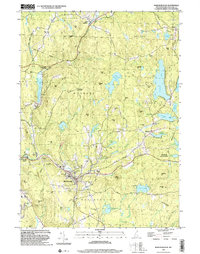
1998 Map of Marlborough
USGS Topo · Published 2002About this map
Marlborough serves as a primary hub in this late-twentieth-century landscape, situated where Minnewawa Brook and Robbins Brook meet. The village character is defined by its social and spiritual centers, including St Francis Ch and Mt Calvary Cem, alongside the industrial legacy of the B & M RR line. To the north and east, the terrain is dotted with high points like Nims Hill and The Pinnacle, while the water network includes prominent bodies such as Silver Lake and Center Pond. The map reveals a transition from the concentrated residential areas of South Keene and Chesham to the protected woodlands of Otter Brook State Park and Leighton State Forest. Local infrastructure is well-marked, from the Gaging Sta near Otter Brook Lake to the County Fairground on the western edge, providing a comprehensive view of the township's organization.
Find a feature on this map
87 named features on this map. Tap any name to fly to it.
Don’t see what you’re looking for? This feature index may not catch every label — zoom into the map to look around manually.
Map Details
Editions of this 1998 Marlborough Map
This is the sole edition of this map. No revisions or reprints were ever made.
Other maps of this area

1898 · Monadnock
USGS Topo · 1:62,500

1898 · Keene
USGS Topo · 1:62,500

1927 · Bellows Falls
USGS Topo · 1:48,000

1930 · Lovewell Mountain
USGS Topo · 1:62,500

1930 · Bellows Falls
USGS Topo · 1:62,500

1932 · Keene
USGS Topo · 1:62,500
1935 · Keene
USGS Topo · 1:62,500

1936 · Monadnock
USGS Topo · 1:62,500

1942 · Keene
USGS Topo · 1:125,000

1942 · Lovewell Mountain
USGS Topo · 1:62,500