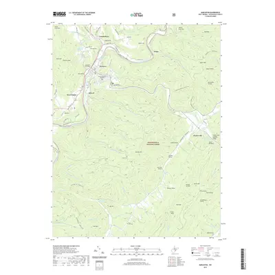
2019 Map of Marlinton
USGS Topo · Published 2019About this map
Marlinton serves as the focal point of this Pocahontas County landscape, where the Greenbrier River meets the winding Knapp Creek. The town's historic core is anchored by the Pocahontas County Courthouse and the Marlinton City Bridge, surrounded by high terrain like Stony Creek Mtn and Bucks Mtn. To the south, the village of Huntersville sits at the base of Devils Backbone, while the Monongahela National Forest covers much of the eastern and southern reaches. The map reveals a deep connection to local land and family history, evidenced by landmarks such as the Adam Moore Chalybeate Spring and numerous family-named hollows like Moore Hollow and McLaughlin Hollow. Modern transportation and conservation efforts are visible in the Greenbrier River Rail-Trail, which follows the river's path through settlements like Stillwell and Beard Heights, repurposing the old rail corridor for recreation.
Find a feature on this map
101 named features on this map. Tap any name to fly to it.
Don’t see what you’re looking for? This feature index may not catch every label — zoom into the map to look around manually.
Map Details
Editions of this 2019 Marlinton Map
This is the sole edition of this map. No revisions or reprints were ever made.
Other maps of this area

1891 · Huntersville
USGS Topo · 1:125,000

1894 · Huntersville
USGS Topo · 1:125,000

1901 · Monterey
USGS Topo · 1:125,000

1922 · Cass
USGS Topo · 1:48,000

1923 · Marlinton
USGS Topo · 1:48,000

1923 · Warm Springs
USGS Topo · 1:48,000

1923 · Mingo
USGS Topo · 1:48,000

1924 · Cass
USGS Topo · 1:62,500

1925 · Mingo
USGS Topo · 1:62,500

1925 · Marlinton
USGS Topo · 1:62,500