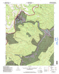
1995 Map of Marlinton
USGS Topo · Published 1998About this map
Marlinton serves as the focal point of this Pocahontas County landscape, situated at the confluence of the Greenbrier River and Knapp Creek. The 1990s terrain reveals a mix of civic infrastructure and protected wilderness, with the town's grid featuring Mountain View Cem and a nearby Radio Tower. To the east, the settlement of Huntersville sits at the base of Huntersville Mountain, providing a gateway to the extensive Monongahela National Forest.
Find a feature on this map
75 named features on this map. Tap any name to fly to it.
Don’t see what you’re looking for? This feature index may not catch every label — zoom into the map to look around manually.
Map Details
Editions of this 1995 Marlinton Map
This is the sole edition of this map. No revisions or reprints were ever made.
Other maps of this area

1891 · Huntersville
USGS Topo · 1:125,000

1894 · Huntersville
USGS Topo · 1:125,000

1901 · Monterey
USGS Topo · 1:125,000

1922 · Cass
USGS Topo · 1:48,000

1923 · Marlinton
USGS Topo · 1:48,000

1923 · Warm Springs
USGS Topo · 1:48,000

1923 · Mingo
USGS Topo · 1:48,000

1924 · Cass
USGS Topo · 1:62,500

1925 · Mingo
USGS Topo · 1:62,500

1925 · Marlinton
USGS Topo · 1:62,500