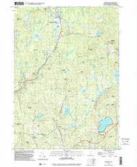
1998 Map of Marlow
USGS Topo · Published 2002About this map
Ashuelot River drainage and the surrounding hill country define this terrain as it appeared in the late 1990s. The village of Marlow sits at the northern end of the quadrangle near Big Pond, while Munsonville anchors the southern landscape along the shores of Granite Lake. The area's agricultural and industrial heritage is visible through scattered labels for sites like Woods Mill and numerous active and former Gravel Pits. Local history researchers will find several well-documented burial grounds, including Jefts Cem and East Cem, which often represent early family farmstead locations.
Find a feature on this map
85 named features on this map. Tap any name to fly to it.
Don’t see what you’re looking for? This feature index may not catch every label — zoom into the map to look around manually.
Map Details
Editions of this 1998 Marlow Map
This is the sole edition of this map. No revisions or reprints were ever made.
Other maps of this area

1898 · Monadnock
USGS Topo · 1:62,500

1898 · Keene
USGS Topo · 1:62,500

1927 · Bellows Falls
USGS Topo · 1:48,000

1930 · Lovewell Mountain
USGS Topo · 1:62,500

1930 · Bellows Falls
USGS Topo · 1:62,500

1932 · Keene
USGS Topo · 1:62,500
1935 · Keene
USGS Topo · 1:62,500

1936 · Monadnock
USGS Topo · 1:62,500

1942 · Keene
USGS Topo · 1:125,000

1942 · Lovewell Mountain
USGS Topo · 1:62,500