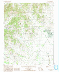
1984 Map of Marmaduke
USGS Topo · Published 1993About this map
Marmaduke sits at the intersection of rural agriculture and rail logistics in Greene County during the early 1980s. The town is defined by its position along the St Louis Southwestern railroad, which cuts a sharp diagonal through the landscape of northeastern Arkansas. This survey reveals a transition between the developed town center and the surrounding drainage network of the St. Francis River basin, characterized by numerous meandering waterways such as Hurricane Creek, Slavens Creek, and Pigeon Roost Creek. Small outlying communities like Henderson and Lafe are documented here, providing a clear view of the area's secondary settlement patterns. The terrain shows the characteristic interplay between low-lying creek bottoms and the slightly elevated Crowley's Ridge area to the west, where Big Creek and Culuer Creek originate, illustrating how the physical geography dictated the placement of farms and rail lines.
Find a feature on this map
14 named features on this map. Tap any name to fly to it.
Don’t see what you’re looking for? This feature index may not catch every label — zoom into the map to look around manually.
Map Details
Editions of this 1984 Marmaduke Map
2 editions found
Other maps of this area

1935 · Rector
USGS Topo · 1:62,500

1935 · Knobel
USGS Topo · 1:62,500

1940 · Gainesville
USGS Topo · 1:62,500

1940 · Marmaduke
USGS Topo · 1:62,500

1941 · Knobel
USGS Topo · 1:62,500

1957 · Poplar Bluff
USGS Topo · 1:250,000

1958 · Marmaduke
USGS Topo · 1:62,500

1958 · Gainesville
USGS Topo · 1:62,500

1958 · Rector
USGS Topo · 1:62,500

1959 · Poplar Bluff
USGS Topo · 1:250,000