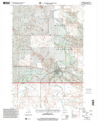
1997 Map of Marmarth
USGS Topo · Published 2001About this map
Marmarth occupies a strategic bend where the Little Missouri River flows through the southwestern corner of North Dakota. In this late twentieth-century landscape, the town serves as a focal point within the Little Missouri National Grassland, surrounded by a complex network of seasonal drainages including Beaver Creek, Mosquito Creek, and Hay Creek. The survey highlights local infrastructure and civic life, from the Rodeo Ground and Riverside Cem on the town's eastern edge to the technical presence of a Substa and Gaging Sta.
Find a feature on this map
20 named features on this map. Tap any name to fly to it.
Don’t see what you’re looking for? This feature index may not catch every label — zoom into the map to look around manually.
Map Details
Editions of this 1997 Marmarth Map
This is the sole edition of this map. No revisions or reprints were ever made.
Other maps of this area

1953 · Miles City
USGS Topo · 1:250,000

1953 · Dickinson
USGS Topo · 1:250,000

1957 · Dickinson
USGS Topo · 1:250,000

1957 · Miles City
USGS Topo · 1:250,000

1958 · Miles City
USGS Topo · 1:250,000

1973 · Kid Creek
USGS Topo · 1:24,000

1973 · Cedar Hills
USGS Topo · 1:24,000

1980 · Pretty Butte
USGS Topo · 1:24,000

1980 · Marmarth
USGS Topo · 1:24,000

1980 · Boyce Creek West
USGS Topo · 1:24,000