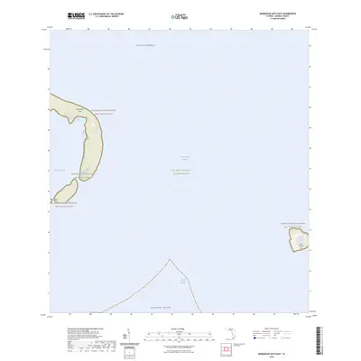
2024 Map of Marquesas Keys East
USGS Topo · Published 2024About this map
The Marquesas Keys form a distinctive atoll-like island group west of Key West, surrounded by the protected waters of the Key West National Wildlife Refuge. This maritime landscape is defined by the shallow waters of Mooney Harbor and the deep Boca Grande Channel, which separates the main atoll from Boca Grande Key to the east. The entire land area is managed as part of the Florida Keys Wilderness, ensuring the preservation of the small mangrove islands like the Gull Keys. Positioned between the Gulf of Mexico and the Straits of Florida, the map illustrates a dynamic environment where the Atlantic Ocean meets the subtropic keys, providing a detailed record of shoreline geometry and reef-edge boundaries essential for understanding the natural history of this uninhabited archipelago.
Find a feature on this map
10 named features on this map. Tap any name to fly to it.
Don’t see what you’re looking for? This feature index may not catch every label — zoom into the map to look around manually.
Map Details
Editions of this 2024 Marquesas Keys East Map
This is the sole edition of this map. No revisions or reprints were ever made.
Other maps of this area

1921 · Key West
USGS Topo · 1:62,500

1943 · Cottrell Key
USGS Topo · 1:24,000

1963 · Cottrell Key
USGS Topo · 1:24,000
1971 · Marquesas Keys West
USGS Topo · 1:24,000
1971 · Marquesas Keys East
USGS Topo · 1:24,000
1972 · Cottrell Key
USGS Topo · 1:24,000

1983 · Dry Tortugas
USGS Topo · 1:100,000

1983 · Key West
USGS Topo · 1:100,000

1989 · Key West
USGS Topo · 1:250,000

1989 · Dry Tortugas
USGS Topo · 1:250,000