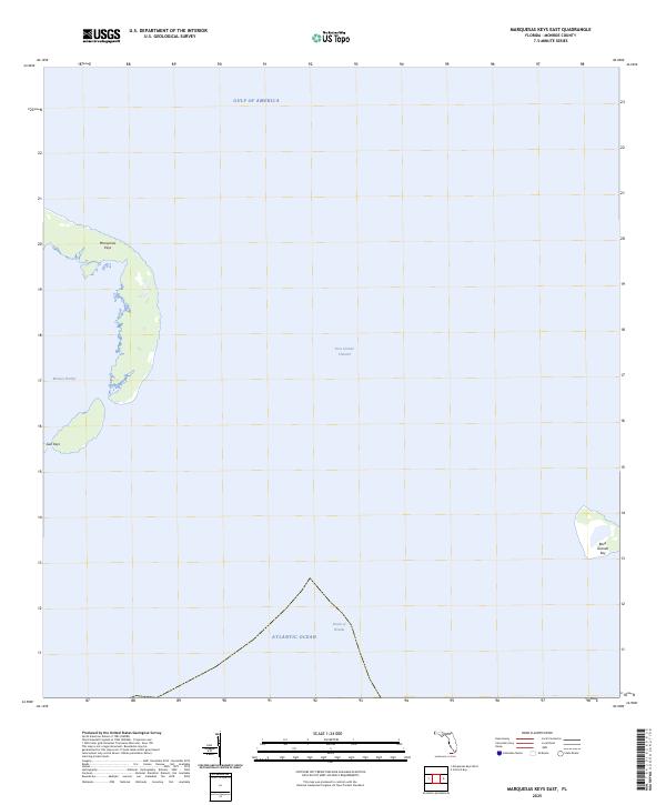
2025 Map of Marquesas Keys East
USGS Topo · Published 2025About this map
Marquesas Keys and the neighboring Gull Keys dominate the western reach of this maritime survey, marking a significant coral atoll formation in the lower Florida Keys. The landscape is defined by the shallow, protected waters of Mooney Harbor, which sits sheltered by the sweeping curve of the islands. To the east across the deep Boca Grande Channel lies the isolated Boca Grande Key, a solitary landmass surrounded by the open waters where the Gulf of America meets the Atlantic Ocean. The southern portion of the sheet is governed by the deep-water currents of the Straits of Florida, illustrating the transition from the shallow harbor environments to the primary shipping channels that have historically guided navigation through these carbonate banks.
Find a feature on this map
8 named features on this map. Tap any name to fly to it.
Don’t see what you’re looking for? This feature index may not catch every label — zoom into the map to look around manually.
Map Details
Editions of this 2025 Marquesas Keys East Map
This is the sole edition of this map. No revisions or reprints were ever made.
Other maps of this area

1921 · Key West
USGS Topo · 1:62,500

1943 · Cottrell Key
USGS Topo · 1:24,000

1963 · Cottrell Key
USGS Topo · 1:24,000
1971 · Marquesas Keys West
USGS Topo · 1:24,000
1971 · Marquesas Keys East
USGS Topo · 1:24,000
1972 · Cottrell Key
USGS Topo · 1:24,000

1983 · Dry Tortugas
USGS Topo · 1:100,000

1983 · Key West
USGS Topo · 1:100,000

1989 · Key West
USGS Topo · 1:250,000

1989 · Dry Tortugas
USGS Topo · 1:250,000