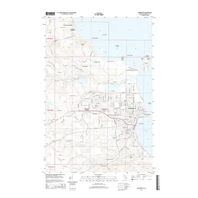
2014 Map of Marquette
USGS Topo · Published 2014About this map
The city of Marquette dominates this Lake Superior coastline, serving as a hub where industrial infrastructure meets the Upper Peninsula’s natural terrain. The shoreline is defined by notable landmarks like Presque Isle and Lighthouse Point, while the interior rises toward Sugarloaf Mtn and Hogback Mtn. This 2014 survey documents the dense residential grid of the city, the sprawling campus of Northern Michigan Univ, and the quiet locations of Park Cem and Holy Cross Cem. Beyond the city limits, the landscape transitions into a network of water bodies and trails, including Lake Enchantment and the N Country National Scenic Trail. The map also captures several falls along the river systems, such as Dead River Falls and Morgan Falls, reflecting the steep topography that leads down to the shores of Marquette Bay.
Find a feature on this map
212 named features on this map. Tap any name to fly to it.
Don’t see what you’re looking for? This feature index may not catch every label — zoom into the map to look around manually.
Map Details
Editions of this 2014 Marquette Map
This is the sole edition of this map. No revisions or reprints were ever made.
Other maps of this area

1907 · Marquette
USGS Topo · 1:62,500

1932 · Harvey NW
USGS Topo · 1:31,680

1932 · Harvey NE
USGS Topo · 1:31,680

1952 · Sands
USGS Topo · 1:24,000

1952 · Ishpeming
USGS Topo · 1:62,500

1952 · Gwinn
USGS Topo · 1:62,500

1952 · Palmer
USGS Topo · 1:24,000

1953 · Marquette NW
USGS Topo · 1:24,000

1953 · Negaunee
USGS Topo · 1:24,000
1954 · Marquette
USGS Topo · 1:24,000