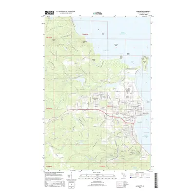
2017 Map of Marquette
USGS Topo · Published 2017About this map
Marquette and its adjacent harbors on Lake Superior define this 2017 survey, showing the city's complex interface with the Lake Superior shoreline. The map documents the extensive campus of Northern Michigan Univ and the industrial infrastructure of the Lake Superior & Ishpeming RR, which remains a vital link to the region's mining heritage. To the north, the protected peninsula of Presque Isle stands near Partridge Bay, while residential expansion is evident in Trowbridge Park and Brookton Corners.
Find a feature on this map
155 named features on this map. Tap any name to fly to it.
Don’t see what you’re looking for? This feature index may not catch every label — zoom into the map to look around manually.
Map Details
Editions of this 2017 Marquette Map
This is the sole edition of this map. No revisions or reprints were ever made.
Other maps of this area

1907 · Marquette
USGS Topo · 1:62,500

1932 · Harvey NW
USGS Topo · 1:31,680

1932 · Harvey NE
USGS Topo · 1:31,680

1952 · Sands
USGS Topo · 1:24,000

1952 · Ishpeming
USGS Topo · 1:62,500

1952 · Gwinn
USGS Topo · 1:62,500

1952 · Palmer
USGS Topo · 1:24,000

1953 · Marquette NW
USGS Topo · 1:24,000

1953 · Negaunee
USGS Topo · 1:24,000
1954 · Marquette
USGS Topo · 1:24,000