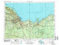
1958 Map of Marquette
USGS Topo · Published 1984About this map
The iron mining and timber heart of the Upper Peninsula is revealed in this mid-century survey, centered on the shipping hub of Marquette. The industrial infrastructure of the iron range is prominent, with the Lake Superior and Ishpeming and Soo Line railroads connecting interior mining centers like Ishpeming and Negaunee to the lakefront ore docks. The landscape transitions from the high peaks of the Huron Mountains in the northwest to the extensive wetlands of the Seney National Wildlife Refuge in the east.
Find a feature on this map
199 named features on this map. Tap any name to fly to it.
Don’t see what you’re looking for? This feature index may not catch every label — zoom into the map to look around manually.
Map Details
Editions of this 1958 Marquette Map
2 editions found

Other maps of this area

1899 · Sagola
USGS Topo · 1:62,500

1899 · Witbeck
USGS Topo · 1:62,500

1907 · Marquette
USGS Topo · 1:62,500

1931 · Cooks NE
USGS Topo · 1:31,680

1931 · Seney SW
USGS Topo · 1:31,680

1931 · Seney NW
USGS Topo · 1:31,680

1931 · Steuben SE
USGS Topo · 1:31,680

1931 · Manistique River NE
USGS Topo · 1:31,680

1931 · Steuben SW
USGS Topo · 1:31,680

1931 · Driggs Lake NE
USGS Topo · 1:31,680