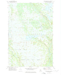
1972 Map of Marsh Creek Pool
USGS Topo · Published 1975About this map
The Seney National Wildlife Refuge dominates this landscape in the early 1970s, showcasing a complex hydraulic network of pools and channels designed for migratory bird habitat. The map reveals the intricate water management of the Upper Peninsula, where the Marsh Creek Pool and Delta Creek Pool sit alongside natural features like the Driggs River. To the south, the Manistique River State Forest borders the refuge, centered on the winding path of the Manistique River. Human intervention is marked by the presence of the Walsh Ditch and several wilderness access routes, including the Riverside Truck Trail. This survey captures the region as a dedicated conservation area, defined by its numerous named water bodies such as Marsh Pool, T Pool, and Duck Creek, which illustrate the wet, low-lying character of the Schoolcraft County interior.
Find a feature on this map
21 named features on this map. Tap any name to fly to it.
Don’t see what you’re looking for? This feature index may not catch every label — zoom into the map to look around manually.
Map Details
Editions of this 1972 Marsh Creek Pool Map
This is the sole edition of this map. No revisions or reprints were ever made.
Other maps of this area

1931 · Seney SW
USGS Topo · 1:31,680

1931 · Manistique River NE
USGS Topo · 1:31,680

1931 · Manistique River SE
USGS Topo · 1:31,680

1931 · Manistique River NW
USGS Topo · 1:31,680

1931 · Blaney SW
USGS Topo · 1:31,680

1931 · Manistique River SW
USGS Topo · 1:31,680

1931 · Driggs Lake SW
USGS Topo · 1:31,680

1931 · Blaney NW
USGS Topo · 1:31,680

1931 · Driggs Lake SE
USGS Topo · 1:31,680

1954 · Sault Sainte Marie
USGS Topo · 1:250,000