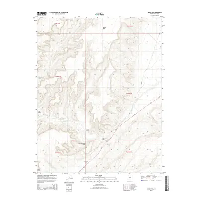
2014 Map of Marsh Pass
USGS Topo · Published 2014About this map
Marsh Pass serves as a critical geographic gateway in this high-desert landscape, where Us-160 follows the natural corridor of Long House Valley. The small settlement of Tsegi sits at the junction of several massive landforms, most notably the towering Skeleton Mesa to the north and the complex drainage system of Tsegi Canyon. This 2014 survey captures the intricate topographical relief of the region, including the winding path of Laguna Creek as it passes beneath sandstone formations. Numerous named canyons, such as Wildcat Canyon, Cobra Head Canyon, and Lone Cottonwood Canyon, branch away from the main valley, illustrating the deeply eroded plateau geography of the Navajo Nation. The map also delineates tribal road networks, including Bia-6486 and Bia-6248, which provide access to the high elevations and remote drainages like Dowozhiebito Canyon and House Canyon.
Find a feature on this map
20 named features on this map. Tap any name to fly to it.
Don’t see what you’re looking for? This feature index may not catch every label — zoom into the map to look around manually.
Map Details
Editions of this 2014 Marsh Pass Map
This is the sole edition of this map. No revisions or reprints were ever made.
Other maps of this area

1883 · Marsh Pass
USGS Topo · 1:250,000

1892 · Marsh Pass
USGS Topo · 1:250,000

1952 · Agathla Peak 2 SW
USGS Topo · 1:24,000

1952 · Boot Mesa
USGS Topo · 1:62,500

1952 · Agathla Peak 2 SE
USGS Topo · 1:24,000

1956 · Marble Canyon
USGS Topo · 1:250,000

1959 · Marble Canyon
USGS Topo · 1:250,000

1961 · Marble Canyon
USGS Topo · 1:250,000
1968 · Kayenta West
USGS Topo · 1:24,000

1968 · Marsh Pass
USGS Topo · 1:24,000