
1892 Map of Marsh Pass
USGS Topo · Published 1892About this map
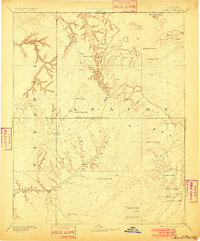
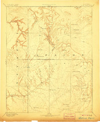
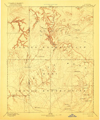
The high plateaus and deep sandstone canyons of the Navajo Indian Reservation Line are captured here during an era of early exploration directed by J.W. Powell. Centered on the critical geographic bottleneck of Marsh Pass, the topography reveals a complex network of ephemeral water sources and traditional landmarks. Named springs such as Chil-Chi-Vi-To Spring and Tu-go-hot-tas-e Spring indicate the vital reliance on small water caches across the arid landscape. The map emphasizes the isolation of the Skeleton Mesa and the massive Zilh-Le-Jini Mesa, where vertical relief defines the movement through the territory. Distinctive geological formations like the Agathla Needle and Cha-ez-kla Rock serve as primary navigation points in a region where travel followed the natural drainage of Moencopie Wash and the steep cuts of Paiute Canyon.
Find a feature on this map
35 named features on this map. Tap any name to fly to it.
Don’t see what you’re looking for? This feature index may not catch every label — zoom into the map to look around manually.
Map Details
Editions of this 1892 Marsh Pass Map
4 editions found
Other maps of this area

1883 · Marsh Pass
USGS Topo · 1:250,000

1883 · Tusayan
USGS Topo · 1:250,000

1886 · Tusayan
USGS Topo · 1:250,000

1886 · Fort Defiance
USGS Topo · 1:250,000

1886 · Escalante
USGS Topo · 1:250,000

1886 · Henry Mountains
USGS Topo · 1:250,000

1886 · San Francisco Mtns
USGS Topo · 1:250,000

1886 · Abajo
USGS Topo · 1:250,000

1886 · Echo Cliffs
USGS Topo · 1:250,000

1891 · San Francisco Mtns
USGS Topo · 1:250,000