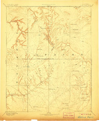
1892 Map of Marsh Pass
USGS Topo · Published 1906About this map
Navajo Creek and its complex drainage systems dominate this reconnaissance study of the high plateau country in northeastern Arizona. Surveyed in 1883, the map documents a landscape defined by massive mesas and isolated volcanic features, such as the prominent Aga-thla Needle and Cha-ez-kla Rock. The terrain transitions from the heights of Skeleton Mesa and Te-en-ta Mesa down toward the central corridor of Marsh Pass.
Find a feature on this map
35 named features on this map. Tap any name to fly to it.
Don’t see what you’re looking for? This feature index may not catch every label — zoom into the map to look around manually.
Map Details
Editions of this 1892 Marsh Pass Map
4 editions found

Other maps of this area

1883 · Marsh Pass
USGS Topo · 1:250,000

1883 · Tusayan
USGS Topo · 1:250,000

1886 · Tusayan
USGS Topo · 1:250,000

1886 · Fort Defiance
USGS Topo · 1:250,000

1886 · Escalante
USGS Topo · 1:250,000

1886 · Henry Mountains
USGS Topo · 1:250,000

1886 · San Francisco Mtns
USGS Topo · 1:250,000

1886 · Abajo
USGS Topo · 1:250,000

1886 · Echo Cliffs
USGS Topo · 1:250,000

1891 · San Francisco Mtns
USGS Topo · 1:250,000