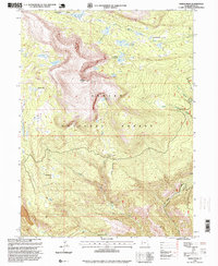
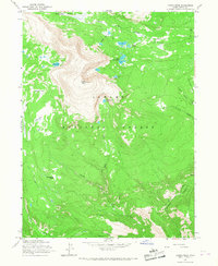
1996 Map of Marsh Peak
USGS Topo · Published 1999About this map
Marsh Peak dominates this high-altitude landscape within the Ashley National Forest, serving as a topographical anchor for a complex network of alpine basins and water systems. The map details the drainage of the South Fork Ashley Creek and numerous small glacial lakes, including Fish Lake, Ashley Twin Lakes, and the cluster at Lakeshore Basin. These water sources are vital to the lower elevations, evidenced by a Gaging Station and the Red Cloud Loop road which provides access through the high country.
Find a feature on this map
25 named features on this map. Tap any name to fly to it.
Don’t see what you’re looking for? This feature index may not catch every label — zoom into the map to look around manually.
Map Details
Editions of this 1996 Marsh Peak Map
This is the sole edition of this map. No revisions or reprints were ever made.
Other maps of this area

1885 · Ashley
USGS Topo · 1:250,000

1906 · Marsh Peak
USGS Topo · 1:125,000

1908 · Marsh Peak
USGS Topo · 1:125,000

1954 · Vernal
USGS Topo · 1:250,000

1958 · Vernal
USGS Topo · 1:250,000

1960 · Vernal
USGS Topo · 1:250,000
1963 · Whiterocks Lake
USGS Topo · 1:24,000
1963 · Leidy Peak
USGS Topo · 1:24,000
1963 · Elk Park
USGS Topo · 1:24,000
1965 · Marsh Peak
USGS Topo · 1:24,000