
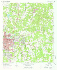
1962 Map of Marshall East
USGS Topo · Published 1964About this map
The eastern reaches of Marshall and the surrounding Harrison County countryside are defined by a complex landscape of early 1960s suburban expansion and deeply rooted rural institutions. The city center, anchored by the Courthouse and the Memorial Hospital, gives way to residential developments like Jasper Heights and Bel Air. This growth is punctuated by a dense network of local education and faith, featuring numerous country churches such as Gainesville Ch and Mt Olive No 1 Ch, alongside schools like Pemberton High Sch and David Crockett Sch.
Find a feature on this map
49 named features on this map. Tap any name to fly to it.
Don’t see what you’re looking for? This feature index may not catch every label — zoom into the map to look around manually.
Map Details
Editions of this 1962 Marshall East Map
2 editions found
Other maps of this area

1943 · Waskom
USGS Topo · 1:62,500

1944 · Caddo Lake
USGS Topo · 1:62,500

1945 · Waskom
USGS Topo · 1:62,500

1946 · Caddo Lake
USGS Topo · 1:62,500

1956 · Tyler
USGS Topo · 1:250,000

1958 · Darco
USGS Topo · 1:62,500

1962 · Marshall NW
USGS Topo · 1:24,000

1962 · Marshall West
USGS Topo · 1:24,000

1962 · Woodlawn
USGS Topo · 1:24,000
1962 · Karnack
USGS Topo · 1:24,000