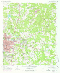
1962 Map of Marshall East
USGS Topo · Published 1978About this map
The Missouri Pacific corridor anchors the eastern half of this Harrison County survey, where the industrial and residential outskirts of Marshall meet the rural East Texas landscape. The city’s eastward expansion is visible through established neighborhoods like Jasper Heights and Bel Air, while the educational landscape is marked by the campus of East Texas Baptist College and several local institutions including Pemberton High Sch and David Crockett Sch. Beyond the city limits, the terrain transitions into the Woodlawn gas fields, where numerous claypits and gravel pits indicate the area's active extractive industries.
Find a feature on this map
58 named features on this map. Tap any name to fly to it.
Don’t see what you’re looking for? This feature index may not catch every label — zoom into the map to look around manually.
Map Details
Editions of this 1962 Marshall East Map
2 editions found

Other maps of this area

1943 · Waskom
USGS Topo · 1:62,500

1944 · Caddo Lake
USGS Topo · 1:62,500

1945 · Waskom
USGS Topo · 1:62,500

1946 · Caddo Lake
USGS Topo · 1:62,500

1956 · Tyler
USGS Topo · 1:250,000

1958 · Darco
USGS Topo · 1:62,500

1962 · Marshall NW
USGS Topo · 1:24,000

1962 · Marshall West
USGS Topo · 1:24,000

1962 · Woodlawn
USGS Topo · 1:24,000
1962 · Karnack
USGS Topo · 1:24,000