
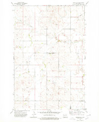
1973 Map of Marshall SW
USGS Topo · Published 1977About this map
The rolling plains of western North Dakota are defined by isolated community landmarks and the winding path of Deep Creek. This mid-1970s survey captures a sparse, agricultural landscape where the Ridgeway Community Center and nearby Ridgeway Ch serve as the primary social and spiritual hubs for the surrounding farmsteads. The infrastructure of the era is marked by scattered Storage Bins, several productive Well sites, and a local School, reflecting a way of life deeply tied to the land and the seasonal rhythms of the northern prairie. Near the center of the sheet, a Gravel Pit indicates local resource extraction, while the township of Myran and the Dunn Co Stark Co boundary line provide a clear geographical framework for researchers tracking property history and rural development patterns in this portion of the Missouri Plateau.
Find a feature on this map
9 named features on this map. Tap any name to fly to it.
Don’t see what you’re looking for? This feature index may not catch every label — zoom into the map to look around manually.
Map Details
Editions of this 1973 Marshall SW Map
This is the sole edition of this map. No revisions or reprints were ever made.
Other maps of this area

1953 · Dickinson
USGS Topo · 1:250,000

1953 · Watford City
USGS Topo · 1:250,000

1957 · Dickinson
USGS Topo · 1:250,000

1957 · Watford City
USGS Topo · 1:250,000

1967 · Watford City
USGS Topo · 1:250,000

1973 · Marshall SE
USGS Topo · 1:24,000

1973 · Boyle
USGS Topo · 1:24,000

1973 · Taylor
USGS Topo · 1:24,000

1973 · Ziner Butte
USGS Topo · 1:24,000
1973 · Hirschville
USGS Topo · 1:24,000