
1984 Map of Marshalltown
USGS Topo · Published 1985About this map
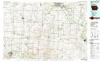
Waterloo and Evansdale anchor the northeastern landscape where the Cedar River flows through a network of conservation areas, including the Katoski Greenbelt Area and the McFarlane County Park. This mid-1980s map illustrates the agricultural heart of Iowa, defined by the winding paths of Wolf Creek and Black Hawk Creek as they traverse the fertile plains between Marshalltown and Vinton. The regional transport infrastructure is prominent, featuring the Chicago And Northwestern rail line and the Cedar Falls Junction, which facilitated the movement of goods between rural hubs like Traer and Dysart. Researchers will find significant land management details, from the Union Grove State Park to the Dudgeon Lake State Wildlife Management Area, reflecting the area's dual character of intensive farming and preserved natural river corridors.
Find a feature on this map
104 named features on this map. Tap any name to fly to it.
Don’t see what you’re looking for? This feature index may not catch every label — zoom into the map to look around manually.
Map Details
Editions of this 1984 Marshalltown Map
2 editions found
Other maps of this area

1888 · Shellsburg
USGS Topo · 1:62,500

1888 · Amana
USGS Topo · 1:62,500

1889 · Amana
USGS Topo · 1:62,500

1889 · Shellsburg
USGS Topo · 1:62,500

1899 · Amana
USGS Topo · 1:62,500

1899 · Shellsburg
USGS Topo · 1:62,500

1901 · Oelwein
USGS Topo · 1:125,000

1903 · Fairfax
USGS Topo · 1:125,000

1903 · Winthrop
USGS Topo · 1:125,000

1954 · Waterloo
USGS Topo · 1:250,000