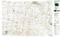
1984 Map of Marshalltown
USGS Topo · Published 1989About this map
Marshalltown and Waterloo anchor this mid-1980s landscape, a region defined by the intricate drainage systems of the Cedar River and Wolf Creek. The survey captures the agricultural heart of Iowa, where township lines like German, Lincoln, and Grant organize a grid of small farming communities including Grundy Center, Reinbeck, and Dysart. Industrial and infrastructure elements are prominent, from the Chicago and North Western rail lines to the powerplant and municipal airport facilities that supported the era's regional growth.
Find a feature on this map
163 named features on this map. Tap any name to fly to it.
Don’t see what you’re looking for? This feature index may not catch every label — zoom into the map to look around manually.
Map Details
Editions of this 1984 Marshalltown Map
2 editions found
Other maps of this area

1888 · Shellsburg
USGS Topo · 1:62,500

1888 · Amana
USGS Topo · 1:62,500

1889 · Amana
USGS Topo · 1:62,500

1889 · Shellsburg
USGS Topo · 1:62,500

1899 · Amana
USGS Topo · 1:62,500

1899 · Shellsburg
USGS Topo · 1:62,500

1901 · Oelwein
USGS Topo · 1:125,000

1903 · Fairfax
USGS Topo · 1:125,000

1903 · Winthrop
USGS Topo · 1:125,000

1954 · Waterloo
USGS Topo · 1:250,000