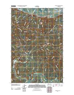
2011 Map of Marshland
USGS Topo · Published 2011About this map
Westport Slough and the Columbia County riverfront define the northern reaches of this coastal range landscape, where the small settlements of Woodson, Marshland, and Kerry are situated along Colvin Rd. The terrain rises sharply from the sloughs and the low-lying Kerry Island to prominent elevations like Tunnel Mountain and Clatskanie Mountain. This high ground is dissected by numerous drainages, including the aptly named Wrong Way Creek and the more significant Beaver Creek. In the southern portion of the quadrangle, the Nehalem River meanders through a valley that serves as a focal point for local landmarks such as Fishhawk Cemetery and the recreational waters of Fishhawk Lake. The map details a complex network of timber and access roads, including Tunnel Rd and Fishhawk Rd, which link remote points like Horseshoe Camp to the main river valleys, illustrating the ongoing relationship between the local geography and the regional timber economy.
Find a feature on this map
57 named features on this map. Tap any name to fly to it.
Don’t see what you’re looking for? This feature index may not catch every label — zoom into the map to look around manually.
Map Details
Editions of this 2011 Marshland Map
This is the sole edition of this map. No revisions or reprints were ever made.
Other maps of this area

1919 · Mayger
USGS Topo · 1:62,500

1940 · Vernonia
USGS Topo · 1:62,500

1941 · Keasey
USGS Topo · 1:62,500

1941 · Clatskanie
USGS Topo · 1:62,500

1941 · Cathlamet
USGS Topo · 1:62,500

1943 · Vernonia
USGS Topo · 1:62,500

1943 · Keasey
USGS Topo · 1:62,500

1948 · Vancouver
USGS Topo · 1:250,000

1950 · Vancouver
USGS Topo · 1:250,000

1950 · Vancouver
USGS Topo · 1:250,000