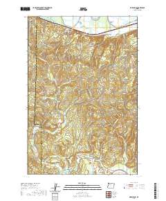
2020 Map of Marshland
USGS Topo · Published 2020About this map
The Nehalem Valley anchors this corner of the Pacific Northwest, where the Nehalem River winds past the settlement of Mist. This 2020 landscape is defined by the sharp transition between the river lowlands and the heavily ridged terrain of Clatskanie Mtn and Tunnel Mtn. Along the northern edge, the Columbia River floodplain is marked by Westport Slough and Uncle Tom Slough, where the small communities of Woodson and Marshland are situated along the transit corridor of the historic Columbia River Highway. In the southern uplands, Fishhawk Lake and the nearby Fishhawk Cem provide a focal point for local genealogy and regional history, illustrating the scattered settlement patterns that remain between the forested heights of Skunk Cabbage Ridge and the water-rich valleys of the Clatsop and Columbia county line.
Find a feature on this map
62 named features on this map. Tap any name to fly to it.
Don’t see what you’re looking for? This feature index may not catch every label — zoom into the map to look around manually.
Map Details
Editions of this 2020 Marshland Map
This is the sole edition of this map. No revisions or reprints were ever made.
Other maps of this area

1919 · Mayger
USGS Topo · 1:62,500

1940 · Vernonia
USGS Topo · 1:62,500

1941 · Keasey
USGS Topo · 1:62,500

1941 · Clatskanie
USGS Topo · 1:62,500

1941 · Cathlamet
USGS Topo · 1:62,500

1943 · Vernonia
USGS Topo · 1:62,500

1943 · Keasey
USGS Topo · 1:62,500

1948 · Vancouver
USGS Topo · 1:250,000

1950 · Vancouver
USGS Topo · 1:250,000

1950 · Vancouver
USGS Topo · 1:250,000