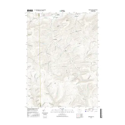
2016 Map of Marshlands
USGS Topo · Published 2016About this map
Pine Creek carves a deep valley through the northern section of this Tioga County landscape, where the small communities of Watrous, Gaines Junction, and Manhattan are situated along the Rte 6 corridor. The geography is defined by a dense network of steep hollows and high points like Elephant Mtn and Hedgehog Point. In the southern half, the terrain becomes increasingly complex as the headwaters of Kettle Creek and Cedar Run emerge from a labyrinth of drainages including Chaffee Run and Billings Branch.
Find a feature on this map
116 named features on this map. Tap any name to fly to it.
Don’t see what you’re looking for? This feature index may not catch every label — zoom into the map to look around manually.
Map Details
Editions of this 2016 Marshlands Map
This is the sole edition of this map. No revisions or reprints were ever made.
Other maps of this area

1899 · Gaines
USGS Topo · 1:62,500

1900 · Gaines
USGS Topo · 1:62,500

1900 · Elkland
USGS Topo · 1:62,500

1946 · Tiadaghton
USGS Topo · 1:24,000

1946 · Antrim
USGS Topo · 1:62,500

1946 · Cedar Run
USGS Topo · 1:24,000

1947 · Galeton
USGS Topo · 1:62,500

1947 · Lee Fire Tower
USGS Topo · 1:24,000
1947 · Oleona
USGS Topo · 1:24,000

1947 · Galeton
USGS Topo · 1:24,000