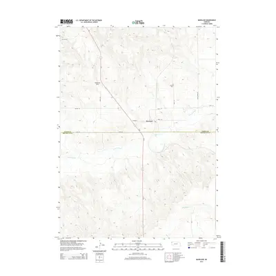
2014 Map of Marsland
USGS Topo · Published 2014About this map
Marsland sits at the center of this Nebraska landscape, situated near the boundary of Dawes and Box Butte counties. The geography is defined by the passage of the Niobrara River, which cuts across the terrain from west to east, passing just south of the main settlement area. Along the river, Gregg Lake and Sand Canyon Cr indicate the water-rich bottomlands that stand in contrast to the more arid surrounding uplands.
Find a feature on this map
18 named features on this map. Tap any name to fly to it.
Don’t see what you’re looking for? This feature index may not catch every label — zoom into the map to look around manually.
Map Details
Editions of this 2014 Marsland Map
This is the sole edition of this map. No revisions or reprints were ever made.
Other maps of this area

1946 · Nonpareil
USGS Topo · 1:24,000

1946 · Box Butte Reservoir West
USGS Topo · 1:24,000

1948 · Box Butte Reservoir West
USGS Topo · 1:24,000

1948 · Nonpareil
USGS Topo · 1:24,000

1951 · Marsland
USGS Topo · 1:62,500

1955 · Alliance
USGS Topo · 1:250,000

1957 · Alliance
USGS Topo · 1:250,000

1958 · Alliance
USGS Topo · 1:250,000
1980 · Coffee Mill Butte SW
USGS Topo · 1:24,000

1980 · Dead Mans Creek
USGS Topo · 1:24,000