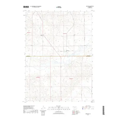
2017 Map of Marsland
USGS Topo · Published 2017About this map
Marsland occupies a central position in this High Plains landscape, situated along the northern banks of the Niobrara River. This 2017 survey reveals a rural Nebraska community where the natural hydrology of the Gregg Lake wetlands and the flowing waters of Sand Canyon Cr intersect with a grid of country roads. The map documents the boundary between Dawes Co and Box Butte Co, showing how local infrastructure like Niobrara St and Co Rd 82 connects the settlement to outlying agricultural lands. Notable landmarks for local historians include the Marsland Cem to the north and the evocatively named Starvation Gulch near the intersection of Manley Rd and the primary highway corridor. The terrain is characterized by subtle elevation changes and drainages that feed into the river valley, defining the spatial layout of this ranching and farming region.
Find a feature on this map
23 named features on this map. Tap any name to fly to it.
Don’t see what you’re looking for? This feature index may not catch every label — zoom into the map to look around manually.
Map Details
Editions of this 2017 Marsland Map
This is the sole edition of this map. No revisions or reprints were ever made.
Other maps of this area

1946 · Nonpareil
USGS Topo · 1:24,000

1946 · Box Butte Reservoir West
USGS Topo · 1:24,000

1948 · Box Butte Reservoir West
USGS Topo · 1:24,000

1948 · Nonpareil
USGS Topo · 1:24,000

1951 · Marsland
USGS Topo · 1:62,500

1955 · Alliance
USGS Topo · 1:250,000

1957 · Alliance
USGS Topo · 1:250,000

1958 · Alliance
USGS Topo · 1:250,000
1980 · Coffee Mill Butte SW
USGS Topo · 1:24,000

1980 · Dead Mans Creek
USGS Topo · 1:24,000