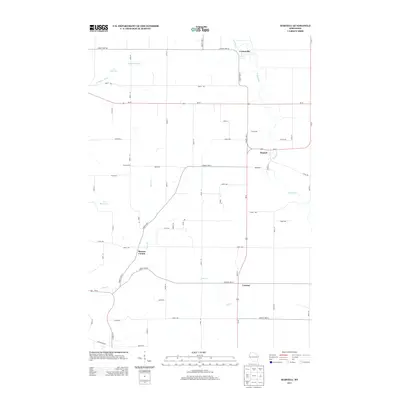
2013 Map of Martell
USGS Topo · Published 2013About this map
The Rush River and Trimbelle River valleys define this Pierce County landscape, where agriculture and small rural intersections persist in the early 21st century. The village of Martell sits at a prominent bend in the Rush River, serving as a focal point near the junction of Us-63 and Wi-29. The map reveals a high concentration of named corners and small settlements, including Centerville, Lawton, and Morton Corner, which reflect a historical settlement pattern of crossroads communities established during the region's dairy and farming peak. Water resources are central to the geography, with the Trimbelle River flowing through a reservoir in the northwest, while smaller tributaries like Goose Cr and Lost Cr drain the central and southern reaches. The gridded road network, marked by numbered streets and avenues such as 870th Ave and 710th St, maintains the orderly rural structure of the Wisconsin countryside.
Find a feature on this map
52 named features on this map. Tap any name to fly to it.
Don’t see what you’re looking for? This feature index may not catch every label — zoom into the map to look around manually.
Map Details
Editions of this 2013 Martell Map
This is the sole edition of this map. No revisions or reprints were ever made.
Other maps of this area

1940 · Maiden Rock
USGS Topo · 1:62,500

1944 · Red Wing
USGS Topo · 1:62,500

1946 · River Falls
USGS Topo · 1:62,500

1949 · River Falls
USGS Topo · 1:62,500

1949 · Baldwin
USGS Topo · 1:62,500

1950 · Maiden Rock
USGS Topo · 1:62,500

1952 · Red Wing
USGS Topo · 1:62,500

1953 · Saint Paul
USGS Topo · 1:250,000

1959 · Saint Paul
USGS Topo · 1:250,000
1974 · River Falls East
USGS Topo · 1:24,000