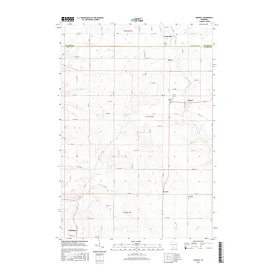
2015 Map of Martell
USGS Topo · Published 2015About this map
The Rush River valley defines the character of this eastern Pierce County landscape, winding south through the settlements of Centerville, Martell, and Lawton. This mid-2010s survey reveals a deeply rooted rural community organized around these river crossings and a dense network of local township roads like 870th Ave and Co Hwy T. Local history is preserved in a concentration of church cemeteries that follow the river's course, including the Rush River Lutheran Cem, Martell Lutheran Cem, and South Rush River Cem. At the southwestern corner, the outskirts of the county seat, Ellsworth, begin to emerge near the headwaters of the Trimbelle River. The map illustrates a high degree of land subdivision across townships T27N R17W and T28N R17W, where agricultural plots are dissected by smaller tributaries such as Goose Cr and Lost Cr.
Find a feature on this map
76 named features on this map. Tap any name to fly to it.
Don’t see what you’re looking for? This feature index may not catch every label — zoom into the map to look around manually.
Map Details
Editions of this 2015 Martell Map
This is the sole edition of this map. No revisions or reprints were ever made.
Other maps of this area

1940 · Maiden Rock
USGS Topo · 1:62,500

1944 · Red Wing
USGS Topo · 1:62,500

1946 · River Falls
USGS Topo · 1:62,500

1949 · River Falls
USGS Topo · 1:62,500

1949 · Baldwin
USGS Topo · 1:62,500

1950 · Maiden Rock
USGS Topo · 1:62,500

1952 · Red Wing
USGS Topo · 1:62,500

1953 · Saint Paul
USGS Topo · 1:250,000

1959 · Saint Paul
USGS Topo · 1:250,000
1974 · River Falls East
USGS Topo · 1:24,000