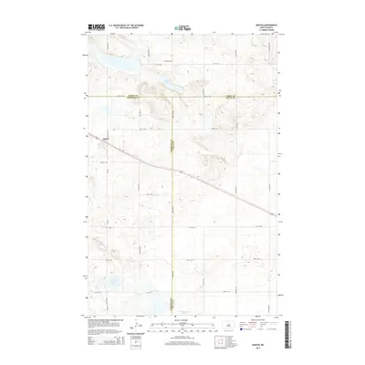
2014 Map of Martin
USGS Topo · Published 2014About this map
The settlement of Martin anchors this central North Dakota landscape, situated at a jurisdictional crossroads where Sheridan, Wells, and Pierce Counties meet. This 2014 survey reveals a transition between concentrated township development and the open, prairie pothole terrain characterized by scattered water bodies like Alkali Lake to the north and Johnson Lake and Sorenson Lake to the south. The rural grid is well-defined by an extensive network of range and section lines, including 22nd Ave NE and 31st St NE. Local history is anchored by sites such as the Reform Cem north of town, which serves as a vital marker for genealogists and regional researchers tracing family lineage in these sparsely populated farming townships. The map illustrates how transportation routes like CR-4225 and the diagonal highway corridor have shaped the development and connectivity of this agricultural hub.
Find a feature on this map
23 named features on this map. Tap any name to fly to it.
Don’t see what you’re looking for? This feature index may not catch every label — zoom into the map to look around manually.
Map Details
Editions of this 2014 Martin Map
This is the sole edition of this map. No revisions or reprints were ever made.
Other maps of this area

1940 · Aylmer
USGS Topo · 1:62,500

1941 · Selz
USGS Topo · 1:62,500

1945 · Manfred
USGS Topo · 1:62,500

1946 · Sheyenne Lake
USGS Topo · 1:48,000

1947 · Sheyenne Lake
USGS Topo · 1:62,500

1948 · Manfred
USGS Topo · 1:62,500

1950 · Manfred NW
USGS Topo · 1:24,000

1950 · Sheyenne Lake NE
USGS Topo · 1:24,000

1950 · Sheyenne Lake
USGS Topo · 1:24,000
1951 · Harvey
USGS Topo · 1:24,000