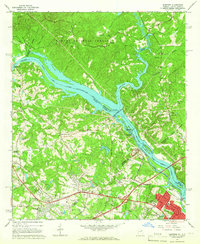
1964 Map of Martinez
USGS Topo · Published 1966About this map
The Savannah River forms the central spine of this 1964 survey, defining the border between Georgia and South Carolina as it flows past the Sumter National Forest. The landscape is dominated by the massive Stevens Creek Dam and its associated power plant, while further downstream, the Augusta City Lock and Dam diverts water into the historic Augusta Canal. This period shows the transition of Martinez and Evans from rural crossroads toward more developed suburbs of Augusta. Local community life is rooted in numerous country churches and schools, such as Abilene Ch and Martinez Sch. Transport infrastructure is prominent, with the Georgia Railroad cutting through Lamkin and Martinez, and the Atlantic Coast Line running near the river. In the southeast corner, the world-famous Augusta National Golf Club is clearly marked, along with the adjacent neighborhood of National Hills.
Find a feature on this map
89 named features on this map. Tap any name to fly to it.
Don’t see what you’re looking for? This feature index may not catch every label — zoom into the map to look around manually.
Map Details
Editions of this 1964 Martinez Map
4 editions found
Other maps of this area

1892 · Mc Cormick
USGS Topo · 1:125,000

1912 · Mc Cormick
USGS Topo · 1:125,000

1920 · Clarks Hill
USGS Topo · 1:48,000

1921 · Augusta
USGS Topo · 1:62,500

1921 · Clarks Hill
USGS Topo · 1:62,500

1922 · Hephzibah
USGS Topo · 1:62,500

1923 · Warrenville
USGS Topo · 1:48,000

1928 · Warrenville
USGS Topo · 1:62,500

1941 · Clarks Hill
USGS Topo · 1:62,500

1942 · Clarks Hill
USGS Topo · 1:62,500