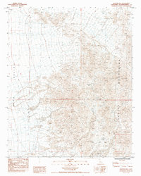
1985 Map of Martins Well
USGS Topo · Published 1985About this map
The Turtle Mountains dominate the eastern landscape of this San Bernardino County survey, giving way to the broad expanse of Ward Valley in the west. This mid-1980s topography documents a region defined by arid-land exploration and mineral extraction, indicated by numerous prospects and a specific shaft located near the center of the range. Water sources are scarce and vital, including Johnsons Well and the noted Martins Well, which is labeled as dry. Access across this desert terrain is limited to a network of 4wd tracks and a Jeep Trail, illustrating the remote nature of the region before modern development. The map provides a detailed look at the township and range boundaries of T 3 N T 2 N and R 19 E R 20 E, anchoring these geological and man-made features in space.
Find a feature on this map
11 named features on this map. Tap any name to fly to it.
Don’t see what you’re looking for? This feature index may not catch every label — zoom into the map to look around manually.
Map Details
Editions of this 1985 Martins Well Map
This is the sole edition of this map. No revisions or reprints were ever made.
Other maps of this area

1942 · Amboy
USGS Topo · 1:250,000

1943 · Amboy
USGS Topo · 1:250,000

1943 · Turtle Mts.
USGS Topo · 1:62,500

1943 · Iron Mountains
USGS Topo · 1:62,500

1954 · Needles
USGS Topo · 1:250,000

1954 · Turtle Mountains
USGS Topo · 1:62,500

1954 · Rice
USGS Topo · 1:62,500

1956 · Needles
USGS Topo · 1:250,000

1956 · Milligan
USGS Topo · 1:62,500

1956 · Iron Mountains
USGS Topo · 1:62,500