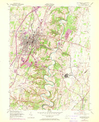
1955 Map of Martinsburg
USGS Topo · Published 1972About this map
Martinsburg serves as the focal point of this mid-century survey, revealing a landscape defined by significant institutional and transport infrastructure. The Newton D Baker General Hospital and Martinsburg Airport occupy large tracts southeast of the city center, while the U of W Va Experimental Farm near Kearneysville highlights the area's agricultural research importance. The winding course of Opequon Creek creates a natural barrier and recreation space at Opequon Golf Course, separating the urban center from smaller crossroads settlements. Railroad connectivity is dense, with the Baltimore and Ohio and Penn Central lines converging in the city. Smaller communities like Van Clevesville, Hedgesville, and Blairton maintain their distinct identities amidst the expanding suburbs and orchards of the eastern panhandle.
Find a feature on this map
40 named features on this map. Tap any name to fly to it.
Don’t see what you’re looking for? This feature index may not catch every label — zoom into the map to look around manually.
Map Details
Editions of this 1955 Martinsburg Map
2 editions found
Other maps of this area

1884 · Harpers Ferry
USGS Topo · 1:125,000

1891 · Harpers Ferry
USGS Topo · 1:125,000

1893 · Harpers Ferry
USGS Topo · 1:125,000

1894 · Winchester
USGS Topo · 1:125,000

1899 · Hancock
USGS Topo · 1:62,500

1901 · Hancock
USGS Topo · 1:62,500

1912 · Williamsport
USGS Topo · 1:62,500

1914 · Martinsburg
USGS Topo · 1:48,000

1914 · Gerrardstown
USGS Topo · 1:48,000

1916 · Gerrardstown
USGS Topo · 1:62,500